
The last of the downpours are moving out of central Connecticut into through eastern Connecticut as of 6:15 p.m.
Given that the rain moved through during rush-hour and many high schools have athletic events planned for tonight, NBC Connecticut declared today a First Alert Weather Day.
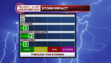
The Storm Prediction Center issued a Severe Thunderstorm Watch for portions of the Mid-Atlantic, but excluded Connecticut. At 5 p.m., there was even a tornado warning northwest of Philadelphia.
Just north of the border in Monson, Mass., a strong thunderstorm hit around 5:30 p.m. and caused extensive damage on Silver Street, with two-foot diameter trees reported down.
All of the rain should be east of the state by 8 p.m. and partial clearing is expected overnight.
Columbus Day weekend looks dry! Saturday and Sunday feature a a blend of clouds and sunshine. Temperatures will be in the lower-60s on Saturday, upper-60s Sunday and in the lower-70s Monday.
Local

Patchy frost is possible Sunday morning as temperatures fall into the 30s in some spots, especially in outlying areas.
The next chance for rain isn't until Tuesday, when another front moves across the area.
