
NBC Connecticut meteorologists are tracking several weather issues for Saturday morning including wintry weather.
Temperatures will drop below freezing in the northwest corner first and the southeast corner last on Saturday morning. Any still water will start to freeze.
After heavy rain and high temperatures on Friday night, flood warnings are in effect for Fairfield, New Haven and Windham counties, while flood watches are in effect in Hartford, Litchfield and Tolland Counties.
In addition to flooding, a winter weather advisory has been issued between 9 a.m. and 4 p.m. on Saturday for Fairfield, Hartford, Litchfield, Tolland and Windham counties.
TIMING
Rain will become scattered by Saturday morning with an increased threat for freezing drizzle in the northern Connecticut counties.
HAZARDS
FLOODING: A combination of heavy rain and snow melt will cause minor flooding on small rivers and streams.
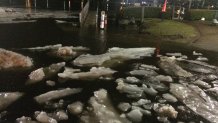
Ice Jam Flooding: As the rivers rise and temperatures warm, ice will break apart. The ice can get "jammed" on river bends, bridges, and other obstructions and create flood issues both upstream and downstream when the jam breaks. There are a number of small rivers that are susceptible to this and the flooding can be dangerous. Minor ice jam flooding has been reported in areas across the state. This is unusual, but not unheard of, for Connecticut.
FREEZING DRIZZLE: As temperatures fall Saturday morning there is a threat for a period of freezing drizzle which could make surfaces very icy.
Local


FLASH FREEZE: A rapid temperature drop will occur Saturday morning which will turn any standing water to ice.
