
In order to get severe thunderstorms you generally need two things - instability in the atmosphere and strong wind shear. Where the two are juxtaposed there's the potential for severe thunderstorms as long as there's a mechanism for the storms to form in the first place.
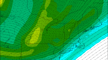
Wednesday appears to be one of those times where the ingredients may overlap for a period of time. The winds near the ground will be light out of the south while the winds a couple miles above our heads will be out of the west at more than 60 mph. When winds change speed and direction with height you have wind shear. In this case we have 40 to 50 knots of wind shear between 0 and 6km up which is a sizable amount.
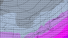
We also have a triggering mechanism moving into southern New England to fire storms in the first place. A cold front and upper level disturbance will swing in from the Great Lakes on Wednesday which should be enough to get showers and thunderstorms going by early afternoon to our northwest.
The question that remains, however, is how much instability will be in place. It's important to figure out how buoyant - or unstable - the atmosphere is. Generally when the air is unusually cold overhead and unusually warm and moist below you have a unstable airmass. The stronger the instability the faster air can accelerate upward resulting in strong updrafts and thunderstorms.
We have a cold pool of air that will be moving in aloft but it's unclear how warm and moist the low levels of the atmosphere will be. This graph from the Short Range Ensemble or SREF (see below) shows a large spread in possible instability values. CAPE (Convective Available Potential Energy) ranges from several hundred j/kg to nearly 1500 j/kg. If the higher amounts of CAPE verify we could very well see some big storms Wednesday evening. If it's on the lower side of things the storms will likely struggle to maintain themselves.

Given the unusually cold mid level temperatures and strong wind shear - if the instability cooperates damaging winds and large hail would be a threat. It's still early but this is something I'm watching closely. At this point we have a threat for strong/severe thunderstorms in the forecast after 4 p.m. on Wednesday. How widepread or significant the threat is remains to be seen.
