
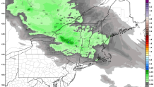
Two storms this weekend on the way- it was another busy day at work! Tonight's snow isn't really that big of a deal but we're going to see a bit of accumulation. 1"-3" of snow should do it across the state with a bit of moisture and plenty of cold air around.
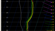
One thing that's notable about the snow this evening is that it should be quite fluffy. This sounding shows a really, really deep layer of temperatures around -15C which should assure big and fluffy snowflakes. These flakes tend to pile up readily.
Any snow tonight will wind down pretty quickly around daybreak tomorrow morning. Most of Saturday looks great! Sunday's storm looks a whole lot more impressive but man it's a tough one to figure out. An area of low pressure to our west is going to redevelop just south of us and turn into a pretty powerful storm east of Cape Cod.

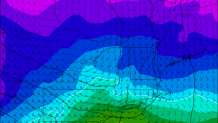
The question is how warm will temperatures get before that storm redevelopment occurs. Can we lock in some cold? We're right on the line between heavy snow and heavy rain (with a bit of sleet mixed in too). The GFS shows this well with the 0 degree isotherm at 850mb (around 5,000 feet up) bisects the state.
A subtle shift in storm track and/or subtle shift in temperature will make a huge difference here. Our forecast is basically a blend of the GFS and Euro right now (the latter being the snowiest and the former being the warmest/rainiest) but there's plenty of bust potential on either side here. I don't feel particularly confident in this one. Let's see what our overnight computer models show and we'll talk again about it in the morning :)
