
The jet stream is plunging to the south and that means the coldest air so far this season will move into Connecticut over the weekend.
A cold front moved through this morning and brought a few showers to the state. However, partial clearing is expected for the balance of the day! High temperatures will be in the lower- and middle-60s today.
Another cold front moves through early tomorrow morning. The day will feature mostly cloudy skies and it will be breezy and cool. Even with highs only in the 50s, but it will be the warmest weekend day!
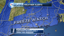
Temperatures plunge into upper-20s to middle-30s Sunday morning. As such, the National Weather Service has issued a freeze watch for the entire state except northern Litchfield County, where the growing season has ended.
Skies will remain mostly cloudy on Sunday with a cold pool of air overhead, and there can be a rain or snow shower! High temperatures will by stuck in the 40s for most. In fact, the hill towns will likely only reach the lower-40s.
Mostly sunny conditions return on Monday, and Monday morning will be the coldest in the next 7-days. Most areas will plunge into the 20s Monday morning, the only exception being shoreline areas where lower-30s are expected.
Local


Even though the coldest air of the season makes an appearance over the weekend, it's short-lived. Temperatures climb heading into the middle part of next week.
Upper-60s are in the forecast for Wednesday and Thursday. Dry weather will dominate with a mix of sun and clouds being the popular weather story.
