
A dreaded cut-off low is going to pay Connecticut a visit this weekend and early next week. The result will be days and days of gloom. Cut-off lows get their name because they effectively become "cut-off" from the jet stream and they can stall out and linger for days on end.
The pattern is a classic one for something like this to form. A dramatic block over Greenland will help force a large dip in the jet stream over New England. What doe it mean for us? An extended period of clouds, chilly temperatures, rain, and possibly even thundersytorms and small hail.
It's tough to time out which days will be coldest or wettest or stomiest but things are not looking great for those who want sunshine. In June or July these cut-off lows are notorious for producing localized areas of excessive rainfall and even severe weather but in early May the impacts should be a bit more muted - though some heavy rain and strong thunderstorms are certainly a possibility.
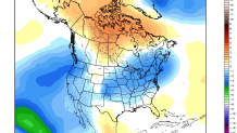
Unfortunately, even after the cut-off low weakens its grip on us the day 11-day 15 period isn't looking so hot (literally) either with a cooler than normal regime over the northeastern U.S.
