
A huge pattern change is coming in the next few days and we will see about as impressive of a weather 180 as you'll ever get in New England. Today's high in Hartford was a miserable 53 degrees - making today's high the 4th coldest on record for June.
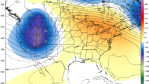
The hideous weather pattern that we've been locked into as been due to an anomalously deep trough and upper level low that has parked itself over the northeastern United States. Unusually cold temperatures in the airmass coupled with an onshore flow off the ocean spelled disaster.
Alas, the pattern is changing in a big way. We have the potential for a 4-day heat wave beginning Sunday as an unusually warm airmass rushes in. We go from a giant trough over the northeast to a giant ridge. At least right now the wind direction appears favorable for big warmth with a general west or northwest flow over New England.
At this point we're forecasting two days in the 90s bookended by 85-90 degree heat but don't be surprised to see all these numbers go up. For the time being, even with exceptional levels of instability being modeled for Monday and Tuesday, the strong ridge of high pressure should keep us capped and hold thunderstorms at bay.
