
Things are going to get pretty interesting around here Thursday afternoon and evening! A pretty classic late developing nor’easter will approach southern New England on Thursday. Significant snow is possible for parts of Connecticut - especially the northwest and northeast hills.
What this storm is missing, however, is a cold high pressure to the north. If we had one we’d be expecting substantial snow down to the shoreline. This storm will be working with marginal and stale cold air - there’s not much room for error!
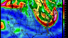
All of our models agree in a late-blooming nor’easter as a powerful piece of upper level energy swings toward the coast. The question is really how quickly the storm develops with a range of scenarios on the table. The GFS, for instance, is the weakest and the last to develop the storm while the European model is substantially stronger and develops the low very quickly. The latter would allow for heavier snow here in Connecticut while to former would result in very little accumulation outside of thr hills. The Euro is probably a bit overdone with how quickly it's developing this storm while the GFS is probably underdone. Regardless, I feel fairly confident that the real "jackpot" from this nor'easter will be north of us in portions of New Hampshire and Maine.
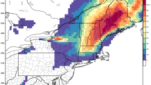
So - what’s most likely here? At this point it seems as if more than 6” of snow is a good bet in the higher elevations of Northwestern Connecticut and also some of the high towns in northeastern Connecticut. A bit of elevation will go a long way in a borderline temperature scenario. The European ensembles show a 50% probability of 6"+ of snow for only the Litchfield Hills - the probabilities drop off quickly southeast of there.
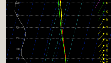
In the Hartford area things are really tough to pin down but at least a portion of the storm (if not a large portion) will be rain or a mix of rain and snow. This is the GFS solution (below) which shows temperatures >32F for the lowest 3 or 4,000 feet of the atmosphere at Bradley Airport as the storm gets going. Not a great look for snow-lovers. While the GFS is the weakest (and therefore the warmest solution) it does show the challenge here with such a borderline airmass. The Hartford area will be the battleground with the rain/snow line!
At this point I'd say a couple inches of snow is the most likely scenario around Hartford but it really will depend on how quickly the storm develops. A slower and weaker solution (like the GFS) would result in little accumulation while something closer to the Euro would mean a few inches - both are reasonable solutions and I'd probably go with a 75% Euro/25% GFS blend.
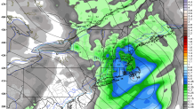
Along the shoreline I wouldn’t expect much at this point but I will say there is one concern. If the storm really “bombs out” quickly and one of the stronger model solutions were to verify (like the Euro or NAM shows) there is the possibility of a flip from rain to snow with a substantial accumulation in a relatively brief period of time. This is going to be very, very tough to forecast much more than 24 hours ahead of time so we’ll see.

The bottom line is that significant snow is a decent bet in the hills but in the valley and along the shoreline significant snow is much less certain - in fact along the shoreline it's quite unlikely. We'll be able to pin things down with much more certainty by tomorrow morning.
