
[[160432565, C]]
Midday Update: The heaviest snow is beginning to taper off from west to east across the state. Already 12"-16" have been reported in some areas and along the I-91 corridor we will see accumulating snow (though not as heavy) through 4 p.m. or so. Drier air will filter in from the northwest later today and get rid of the snow once and for all.
One thing that's worth mentioning again is just how exceptional the thunder and lightning has been with this storm. This has been one of the most prolific lightning producers I've ever seen. Remarkable.
Previous discussion below:
Nothing has really changed since my post last night. A super impressive quick hitting storm is going to result in exceptionally heavy snowfall rates over the next few hours. Lots of lightning and thunder will occur to - this storm is going to be exceptional. I'm using a lot of adjectives and superlatives for this storm because it deserves them.
Most of our computer models have at least 1.0" of liquid across the state and I do think there will be a narrow band of incredible snowfall rates later this morning. Here's the reason why.
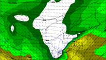
An area of low pressure is going to close off at about 10,000 feet above our heads and that is a hallmark of all of our big snowstorms in New England. Being under or just to the northwest of this feature is critical in getting into the best banding.
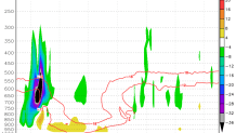
One feature that's also been consistent in our computer modeling is the fact we're looking at violent upward motion where the temperature is close to -15C. This is the temperature at which snowflakes form most efficiently AND the favored type of snow crystal is a dendrite. Dendrites tend to pile up and accumulate quickly as the branches of the snowflakes get intertwined with one another. You can pull off crazy snow:liquid ratios when this signature develops - sometimes on the order of 20:1.
Here's the bottom line...
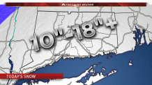
- 10"-18" statewide - if the banding really goes to town and becomes persistent we could see even higher totals in a localized area.
- Extremely heavy snowfall rates 7 a.m. to 2 p.m. shutting off from west to east.
- Snow winds down between 2 p.m. and 6 p.m.
- Snow will be of a heavy consistency first and then become a bit fluffier as the storm goes on.
- Wind gusts up to 40 mph are possible on the coast especially
