
Much of the state is still digging out from yesterdays nor'easter. Snowfall totals varied from 9.5 inches at the shore to nearly 20 inches in parts of Hartford and Tolland counties. We have even more snow in the forecast for tonight and Sunday night.
[HAR] Playing in the Snow
NBC Connecticut meteorologists have issued a First Alert for tonight's snow which could lead to more issues on the roads.
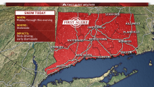
Today will feature mostly sunny skies with temperatures only reaching the low to middle 20s. Winds will make it feel even colder with wind chill values of 5 to 15 degrees.
Roads will become snow-covered tonight with light snow developing between 8 and 10 p.m.
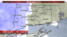
The snow comes to an end tomorrow morning by 8 a.m. Tomorrow's weather will feature partly cloudy skies with high temperatures in the middle to upper 30s.
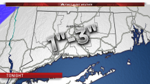
We're forecasting one to three inches throughout the state. Some isolated areas could see up to four inches.
We're also watching another storm system for Sunday night into Monday. Right now it looks like this will feature a mix of snow and sleet Sunday night, transitioning to plain rain by Monday morning.
