
After record warmth not too long ago we've got a big change on the way. Our updated computer models continue to show snow, sleet, rain, and thunder across parts of the state on Thursday.
There are still a few questions that remain. The biggest one that I have is whether or not the snow will accumulate. It appears the best chance of that happening is in the hill towns of Litchfield County above 1,000 feet. Temperatures near the ground will be coldest here and snow will begin falling by late morning. One of my favorite high resolution models is the NCAR ensemble. This graphic shows the probability of temperatures remaining below 32F early in the afternoon tomorrow - there's a clear signal of near freezing air in the highest elevations of northwest Connecticut. A slushy 1"-2" is possible for the hills.
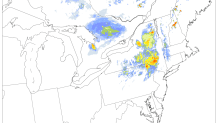
Elsewhere in Connecticut there is the chance for some snow and sleet - even down to the shoreline around New Haven. Enough lingering cold air and some dry air that will result in evaporational cooling as the precipitation begins will be sufficient for a few flakes or pellets. You can see the dry air on this sounding valid at 10 a.m. around Hartford.

This dry air will allow the atmosphere to cool - as snow falls through this dry column the air will cool as the atmospher saturates. This could promote a brief period or snow or sleet even down to the New Haven area - but this will be brief. Any accumulating snow will be confined to the hilltowns.
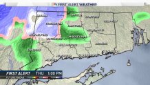
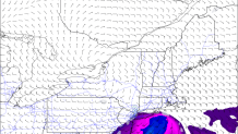
Temperatures will warm above freezing and any snow will change to rain across the state by late afternoon. The storm will strengthen as it moves into Connecticut with a bit of instability present as well giving us a few thunderstorms and areas of heavy rain are possible. There's an outside chance of a gusty strong storm on the Sound as a bit of surface-based instability tries to work north. The NAM model shown here depicts enough instability for strong thunderstorms over Long Island but not quite enough here in Connecticut. This is worth watching.
With a few flakes in the forecast - how common is October snow? Since 1905 (110 years) snow has been reported in the Hartford area on 45 calendar days but snow has only accumulated 4 times which includes the epic October 2011 snowstorm.
- October 29, 2011 - 12.3"
- October 10, 1979 - 1.7"
- October 19, 1972 - 0.4"
- October 30, 1925 - 0.1"
- October 18, 2015 (and 39 previous days) - Trace
In the hills, it's a different story. There was a bit of snow on Saturday in Litchfield County and at the summit of Bear Mountain (over 2,000 feet) Jim Dayton sent in this picture of snow that had accumulated there.

In Norfolk, the Cooperative Weather Station at the Great Mountain Forest has picked up measureable snow 33 times in their 73 years of weather observing. A trace of snow occurs almost every October.
Local


Get the full forecast here.
Connect with me on Facebook and Twitter!
