
A warm, fairly tranquil weekend is on tap before multiple threats for snow next week.
A flurry is possible this evening but it will be harmless, then snow and rain showers of greater consequence move through overnight.
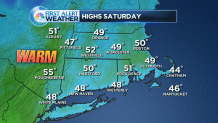
Temperatures soar to near 50 tomorrow with a blend of clouds and sunshine. A stray rain shower is possible late, especially in northern areas of the state.
Sunday's also near 50 with an abundance of clouds.
Rain going over to snow is likely Sunday night into Monday. A coating to 2 inches of snow are possible by daybreak Monday.
Tuesday should be issue-free in the weather department before a major storm threatens in the midweek timeframe.
There is high confidence that the storm forms and high confidence in a heavy precipitation event for Connecticut between Tuesday night and Thursday, but First Alert forecasters aren't sure if it will be snow, an icy mix or rain.

The value to be found in the forecast at this time range is that people with plans in that time range should have an alternate idea in mind, but hold off on making a decision this far out if possible.
