
Severe thunderstorms remain possible Wednesday evening across parts of Connecticut. Of course, as is almost always the case with severe thunderstorms, there are some questions that remain.
My biggest question is how much sunshine we'll see tomorrow afternoon across the state. The more sunshine the warmer temperatures will get and the more instability that will develop. As I mentioned yesterday temperatures about 20,000 feet above our heads get quite cold tomorrow evening - the question that remains is how warm and moist it will be near the surface. The warmer and moister near the ground - and the colder aloft - the stronger the instability. Instability is essential to thunderstorms.
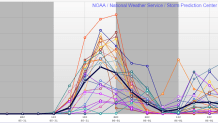
One way to visualize the amount of instability in the atmosphere is looking at something called CAPE or Convective Available Potential Energy. Basically, the more CAPE the faster parcels of air can accelerate up. The faster that acceleration the more powerful a storm. Above is a plume diagram showing 21 different projections of CAPE from our Short Range Ensemble Forecast. If the higher CAPE values verify (which would happen with more sunshine and warmer temperatures) the bigger the storm threat we would see.
Instability is just one ingredient for a storm. Wind shear, or how winds change speed and direction with height, is another ingredient that's critical for storms. There's a boatload of wind shear around tomorrow which would allow storms to organize rapidly with a wind and hail threat as long as there's adequate instability

There is a greater than normal risk for large hail in Connecticut tomorrow given the relatively low freezing levels which will prevent hail stones from melting too much on their way down to the ground.
Local


A few scattered storms are possible as early as 4 p.m. in the hill towns tomorrow but more widespread activity should hold off under around and after 7 p.m. Even though the best chance of storms is across the interior - strong storms are possible across the shoreline as well.
