

NBC Connecticut Meteorologist Darren Sweeney delivers Connecticut's most accurate forecast every weekend morning on NBC Connecticut. He also enjoys covering breaking weather during the week live in the studio and in the field.
Darren joined the StormTracker team in October 2008 and has the recognition from the American Meteorological Society (AMS) with their seal of approval, as well as the National Weather Association (NWA) along with their seal of approval.
A Connecticut native, born and raised in West Hartford, Darren is happy to be forecasting for the station he grew up driving by and watching almost every day.
Darren's fascination with weather began at a young age through all of New England's wild weather extremes. His family knew he was captivated by storms because when everyone was going inside to take shelter, Darren would grab a video camera and go outdoors!
Darren has experience with forecasting New England weather. As a meteorologist for a Springfield TV station, Darren won two Associated Press awards for coverage of historic flooding in October 2005 and for Best Weathercast in 2006. He also reported live during severe weather events, most recently the massive flooding that took place along the Merrimack River in May 2006. More recently, he was honored with a “Breaking news” award by the Connecticut Society for Professional Journalists for his coverage of the 2009 EF-1 Wethersfield tornado.
Before returning to New England, Darren gained experience forecasting severe weather and chasing hurricanes for WFTX-TV in Fort Myers, Fla., where in a couple of instances, he was deployed to New Orleans to help sister stations cover Tropical Storm “Isidore” and Hurricane “Lilly” in 2002.
During his tenure at NBC CONNECTICUT, Darren has covered some of the biggest storms of his career. He was a part of the team that forecasted during Superstorm Sandy, Hurricane Irene as well as many tornado touchdowns.
Darren earned his Bachelor's degree from Central Connecticut State University and went on to earn his Master's degree at Syracuse University's highly regarded Newhouse School of Communication. In 2003, he graduated from Mississippi State University's Broadcast Meteorology program.
During his spare time, you'll find Darren on one of his famous road trips exploring beautiful New England (especially during the summer). Darren is also proud to be a tenured Associate Professor at his alma mater at CCSU teaching in the Department of Journalism. He enjoys mentoring students who are looking to get into the exciting field of journalism and broadcast journalism. He serves on the board of the Connecticut Society of Professional Journalists. Darren volunteers his time at many events raising money and awareness for different types of cancer research. You will also often find Darren involved with helping homeless animals finding good homes. His motto is “Adopt Don’t Shop.”
The Latest
-

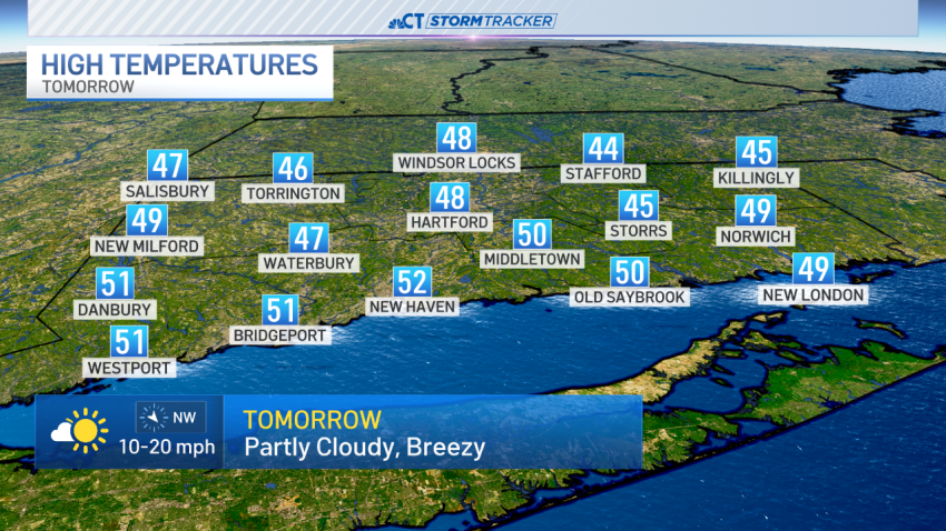
Scattered showers and thunderstorms to end weekend, warming trend this week
Our StormTracker meteorologists are tracking a fast moving system that brings a round of showers and thunderstorms as we wind down the weekend. While widespread rain is not expected, a few heavier downpours or stronger storms moved through during the afternoon. Some storms dropped small hail.A couple of areas of moderate to possibly heavy rain are still possible late...
-
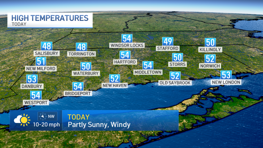
Cool and breezy to start the weekend, with the chance of scattered showers
A storm system nearby kept clouds, breezy conditions, and the chance for showers in the forecast on Saturday. While it wasn’t a washout of a Saturday, a couple of scattered showers moved across the state. We also saw a few more numerous showers during the afternoon. Temperatures remained below average for this time of the year. The average high...
-
Scattered showers possible this evening
It’s the last weekend of March! Sunshine and wind gusts over 20 mph started the weekend and scattered showers are possible this evening. A weak system will pass through the northeast tonight and bring the chance for a few scattered showers. The system will move through quickly and any showers and clouds will clear out by sunrise on Easter Sunday….
-
Increasing sunshine and wind to end the week, start the weekend
The system that brought the state a couple of days of rain will continue to pull away today. Drier air moves in on the backside of the storm along with wind gusts of 20 to 30+ mph. The sunshine and wind will carry into the weekend with some gusts on Saturday continuing over 25 mph. A system will bring a…
-
Sunshine returns along with breezy conditions to end the weekend
Saturday’s storm brought the state anywhere from 1.5″ to just under 4″ of rain across the state. As the storm pulls away, the sunshine returned and a breeze continued through the afternoon. The wind chill or “feels-like” temperature will remain mostly in the 30s today with some upper 20s in the hills. Less wind is in the forecast for Monday…
-
Heavy rain out of Connecticut, breezy winds develop overnight into Sunday
Heavy rain and strong winds battered Connecticut Saturday afternoon, causing tough conditions across the state. A flood warning (not river related) is in place for shoreline areas of Fairfield county through 8:45 p.m. A flood watch has been issued through Sunday morning due to the amount of rain expected. The rain picked up in intensity this afternoon but that heavy…
-
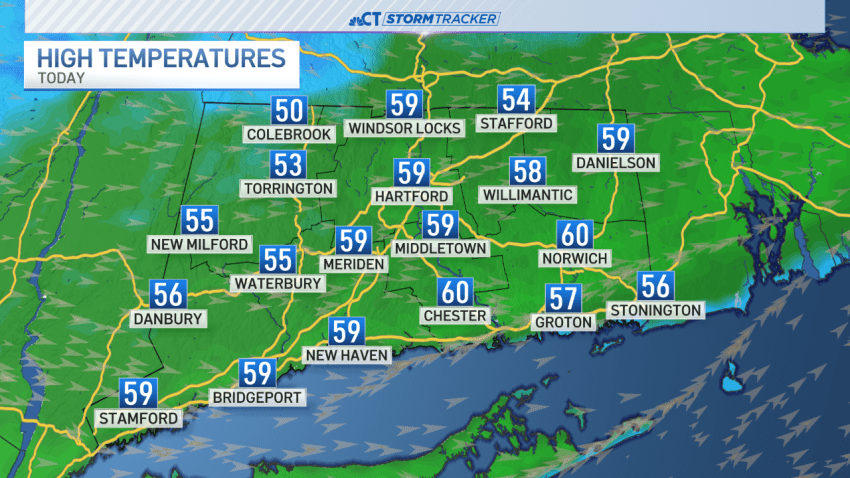
A sunny, breezy, and mild end to the weekend, turning cooler this week
A weak front moved through the state this morning with a few showers. The rest of the day will feature sunshine and clouds mixed along with a strengthening breeze. Along with the breezy conditions, mild temperatures continue. The average high for today is 47 degrees. The forecast brings temps between 55 and 60 degrees. The trend for the week ahead…
-
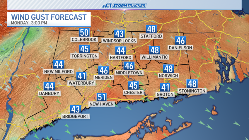
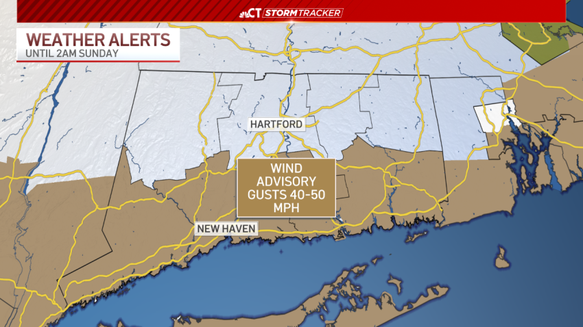
Strong to possibly damaging winds expected for start of new workweek
This weekend’s storm has moved away from the state, but it is bringing a round of strong to possibly damaging wind gusts for the start of the new workweek. Wind advisoies have been issued for the state for Monday. The strongest winds are expected tomorrow afternoon with gusts that could top 50 mph. When winds approach 50 mph tree damage…
-
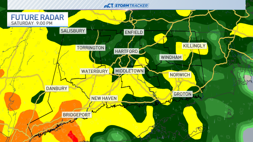
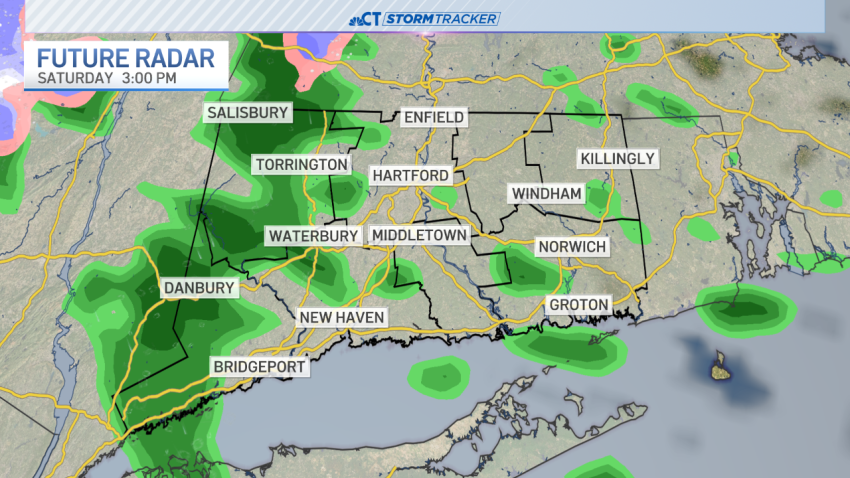
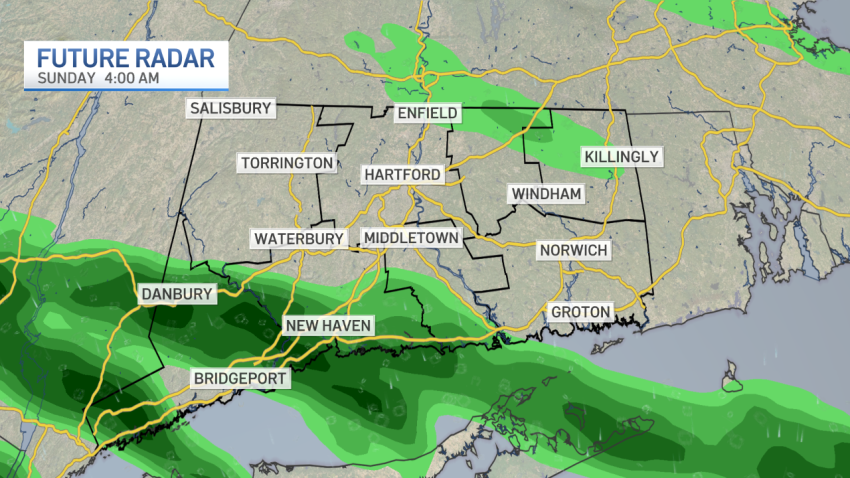
Heavy rain, wind and even some snow possible this weekend
Our StormTracker meteorologists are tracking heavy rain and the low possibility of snow this weekend. Heavy rain is moving into Connecticut Saturday night. A flood watch has been posted for the entire state for late Saturday into Sunday morning. An embedded thunderstorm is likely with the downpours this evening and tonight. One to two inches of rain is likely before…
-
Record warmth to end the first weekend of March
After a rainy Saturday, sunshine has returned on Sunday and we reached record warmth to end the first weekend of March. Sunday has milder temperatures with highs in the upper 50s and 60s statewide. With a high of 65 in Windsor Locks and 64 in Bridgeport, we have officially broken the record for high temperatures for today. It’s still possible…
