
Right off the bat it seems important to say that the fact we're even discussing severe weather on February 28th is pretty wild. The setup is very very complex and very convoluted - this is a tough forecast!
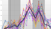
There's no question that there is an elevated severe weather threat tomorrow. We have a very unusual (for the time of year) combination of shear and instability. These are the two pieces that are necessary for severe thunderstorms to develop. These graphs off the short range ensembles (SREF) show very impressive shear and enough instability for some really intriguing storms - including supercells!

But there are some big cavaets here. For one, it's unclear how the severe storms over the midwest and Great Lakes will evolve tonight. Secondly, there's not much of a trigger tomorrow afternoon and evening during the maximum shear/instability combo. What do I mean by that? The best forcing (i.e. cold front) is displaced well to the west. Just becayse we have a combination of shear and instability large enough for severe storms it doesn't necessarily mean storms will form but rather indicates that if storms form they have the potential to become severe.
Our in-house WRF model - the RPM - has been all over the place with where and when thunderstorms will develop. Other high resolution models (including the 3, 4, and 12km NAM) have been equally jumpy with location and timing of storm development. This adds to the uncertainty.

The bottom line is that there is most certainly a severe weather threat tomorrow - including damaging winds and tornadoes. That threat, however, is conditional on thunderstorms developing in the first place during the late afternoon and early evening. For now we'll leave the severe weather impact at low/medium. If it becomes clear storms will develop and be coincident with maximum instability and shear in the early evening then the numbers will need to be boosted.
