
Getting morning severe thunderstorms in southeastern Connecticut is not terribly unusual. There have been other example of storms racing north from Long Island and causing mischief in New London County and South County, Rhode Island. Today's storms were no exception.
The storm was not preceded by an official warning for some reason but we knew these storms looked like trouble. Prior to the storm's arrival we began streaming coverage and sending out social media messages for people to watch out.
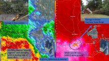
What was so concerning to us was the extreme velocities being picked up by doppler radar. A "bowing segment" was accompanied by winds over 80 mph at the bow's apex several thousand feet above the ground. In essence, the strong winds in the storm were forcing the storm to bow out or race forward.

In fact, as this storm moved over Groton it produced a 95 mph wind gust on the north crane at Electric Boat. Just nearby, you can see the incredible display on a street corner as the winds picked up, transformers blew, and trees snapped below.
Local


The storm was a classic morning severe weather event along the shoreline. Very moist and humid air with a somewhat unstable atmosphere (CAPE values of about 1,000 j/kg indicate some instability). Above the ground very strong winds produced strong shear values which allowed storms to organize and mix some of this high momentum air to the ground. This was maximized near the bow segment's apex which tracked from Waterford into New London, Groton, and Ledyard.
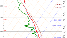
The weather balloon launch (pictured above) from Long Island shows the instability and strong winds throughout the atmosphere. The lack of a stable layer (inversion) at the surface allowed winds to mix readily to the surface.
Sadly, 1 man was killed when a tree fell on his car. This narrow band of destructive winds moved through a populated part of the state knocking down trees and wires in too many neighborhoods to count.
