
NBC Connecticut Meteorologists have issued a First Alert for strong to potentially severe thunderstorms this evening.
The greatest threat for strong storms exists through portions of Litchfield and Fairfield counties.
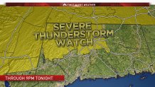
The National Weather Service has issued a Severe Thunderstorm Watch for Litchfield and Hartford counties until 9 p.m. this evening.
The risk for tonight's storms has caused many towns and cities to either postpone or cancel their firework festivities. Click here for a complete updated list on if your city or town has cancelled/postponed tonights event.
While a few scattered showers can be expected through the afternoon the main thunderstorm threat holds off until after 6 p.m.
Here's a look at Live First Alert Interactive Radar,
Local


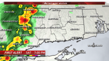
Storms are expected to move into Litchfield and Fairfield counties between 6 and 7 p.m. Take a look at First Alert Future Radar at 7 p.m. this evening. You can see a line of strong thunderstorms moving into the state.
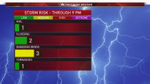
The greatest storm threat with these storms are damaging winds followed by localized flooding issues.
The storms will move east through the evening impacting New Haven and Hartford counties by 8 p.m.
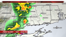
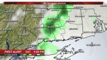
The storms will drastically weaken as they continue east into eastern Connecticut as the atmosphere won't be as unstable. Here's a look at First Alert Future Radar at 9p.m.
Make sure to download the NBC Connecticut App for the latest forecast and live interactive radar. Click here for more details on how to download it.
