
There have been some issues on the roads early Monday morning. A serious crash closed part of Route in Vernon and a UPS truck rolled over on Interstate 84 West in Tolland overnight.
A break in the heavier precipitation will provide a lull in the action across most of Connecticut through the day today. Occasional light wintry mix and rain is expected through midday.
The governor said that state offices will be open for regular business hours Monday.
“It is slick in some spots but still manageable, so we are advising everyone that if you need to travel you should give yourself extra time and take it slow,” Gov. Ned Lamont said in a statement. “Leadership from state offices will remain in enhanced monitoring status throughout the day today as some additional snow, sleet, and freezing rain are expected to impact the state during the Monday afternoon and evening hours. I will stay in close contact with them throughout the day and will provide additional updates as necessary.”
Winter storm warnings are in effect for Litchfield and northern Fairfield counties.
Local
A Winter Weather Advisory is in effect for Hartford, Tolland, Windham, New Haven, Middlesex, and northern New London counties.
As of Sunday night a half foot of snow fell in the Northwest Hills along the Massachusetts border. In the Hartford area, around 3 inches of snow and sleet accumulated. Along the shoreline and inch of snow from the afternoon was washed away.
Minimal additional accumulation of snow and sleet is expected through Monday morning.
Take a look at interactive radar which shows the mixed precipitation slowly pushing to the north.
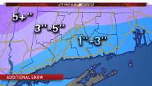
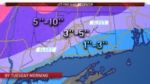
A period of heavier snow is expected to redevelop Monday afternoon in western Connecticut and Monday evening and night across the rest of the state. An additional 1 to 3 inches of accumulation is expected by Tuesday morning. Locally higher amounts are possible.
