
5 p.m. Saturday update: A new advisory from the National Hurricane Center moves Hurricane Jose a little further away from Connecticut.
11 a.m. Saturday Update: A new advisory from the National Hurricane Center is similar to the one at 5 a.m.
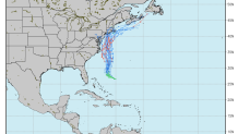
5 AM Saturday Update: A new advisory from the National Hurricane Center this morning shows little change from last night. The track of Jose keeps Connecticut in the "cone of uncertainty." The odds of Connecticut experiencing tropical storm force winds (winds sustained over 39 mph) have increased throughout the state.
The greatest chance for tropical storm conditions is in southeastern Connecticut especially right along the shoreline from Groton to Stonington. We're continuing to look over new data and will have several updates throughout the day.
________________________________________________
It appears we have a good 'ol fashioned American vs European model fight brewing with Hurricane Jose. The two spaghetti plots of the GFS and European ensembles are very different - the former being closer to the coast and the latter being further out to sea.
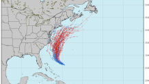
The differences in track make a huge difference in terms of what kind of impact Jose would have here in Connecticut. More often than not a blend of the two disparate model camps yields the best forecast - though it's important to not the Euro is typically the better model. With that in mind here is what I'm thinking in terms of local impact probability for Tuesday and Wednesday when Jose makes its closest pass.
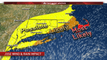
A scenario painted by the GFS ensembles is possible and it would be a significant wind, rain, and coastal flooding storm. At least for now this seems like the least likely scenario. One thing that makes me think it's unlikely is the fact the jet stream pattern is generally not the pattern that fits most New England tropical storm and hurricane strikes. Generally, you want a deep trough of low pressure to capture the hurricane and slingshot it north.
A more likely scenario is more of a glancing blow with some rain and some wind but nothing that would result in more than a handful of power outages.
Still, it's important to watch the path of this storm. Sometimes the least likely scenario is the one that verifies and that scenario is still in the cone of uncertainty. What I am confident in is that even with a "direct hit" the storm will not be of hurricane strength. Cold water temperatures and slow forward motion of the storm should manage to weaken Jose relatively quickly.
