
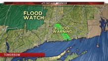
Around 1" of rain is expected to fall across the state Tuesday. With no snow on the ground to melt this rain would not normally be enough to result in flooding but this may be a different case. Existing ice jams on the Connecticut River and the Housatonic River may cause issues as river levels begin to rise as the rain runs off into the state's larger rivers.
Over the last few days we have seen river levels drop across the state but the river levels remain stubbornly high upstream of the two main ice jams in the state at the East Haddam Swing Bridge and near the Kent School. The concern tomorrow is heavy rain causing river levels to rise and forcing the large ice jams to move around some. These ice jams are very unpredictable and if the jams were to reconfigure themselves in a way that the river flow was constricted even more than flooding upstream may begin again.
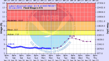
It's hard enough to predict how much rain will fall and how much rivers will rise. Trying to figure out how chunks of ice will move and if they'll get stuck again on river banks or obstructions like bridges is next to impossible. While serious flooding seems unlikely it cannot be ruled out and we'll have to watch it closely.
One other possible issue on Tuesday is strong gusty winds. At this point gusts over 45 mph seem unlikely. Very powerful winds just a few thousand feet above our heads (75+ mph) will be roaring and should remain bottled up there. A strong inversion means there is a strong stable layer near the ground which effectively prevents the high momentum air from mixing down to the surface. Things such as thunderstorms or gravity waves can start to do funky things but at this point damaging wind gusts do not seem likely.
