
Odds of a significant winter storm this weekend continue to increase and I'm quite confident we've got a mess on our hands Saturday night and Sunday. I'm expecting snow to develop across Connecticut between 7 p.m. and 11 p.m. Saturday and then the question is when do we see a transition to sleet and freezing rain?
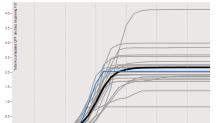
This storm is going to be loaded with juice. Moisture streaming up from the Gulf of Mexico means we're going to get a lot of precipitation. Most models show around 2" of melted precipitation - that's really significant. The plume diagram above from the GFS ensembles show the heavy amounts on virtually ever ensemble member.
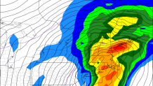
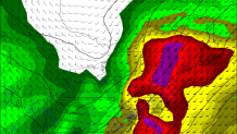
The storm is unlikely, however, to be all snow. While we can't rule out a snowier solution most of our computer models show a lot of warm air moving in aloft by Sunday morning. These two graphics (below) off the GFS computer model show the large tilt to this storm with height. At the surface the storm's center will be near Connecticut while about 10,000 above our heads the storm will actually be closer to Burlington, VT! This is a classic setup for cold air hanging on near the ground but milder air moving in at cloud level.
So we're left with the question of just how much cold air remains at the surface and how much warm air comes in aloft. A degree or two will make a big difference and 50 or 100 miles in storm track will too! The colder air residing under warmer clouds is a good combination for ice. Here's what's most likely at this moment.
- Accumulating snowfall down to the shoreline starting Saturday evening.
- Snow changes to sleet and freezing rain in most locations on Sunday.
- Significant accumulations of snow, sleet, and freezing rain possible.
- A narrow zone of significant icing (freezing rain) may cause issues for trees and power lines.
- More specific storm totals and change over times are to be determined.
- Challenging travel conditions will exist for a good chunk of Sunday.
- Bitterly cold moves in for Monday and any slush will freeze solid.
