
This has all the makings of a classic. A powerful nor'easter will move up the coast producing a heavy burst of snow throughout southern New England. Of course - there are still some questions that I'll dive into in just a bit. First, what we know.
- Over 6" of snow is extremely likely with over 12" of snow now a good bet.
- Current forecast is 12"-18" of snow statewide with locally higher amounts to 24" - especially in the hills.
- Snow begins around daybreak with the heaviest snow between 10 a.m. and 8 p.m. This time table may change a couple hours in either direction.
- Wind gusts over 40 mph at the shoreline may result in blizzard conditions.
- Where exactly does the storm track - too far east and it's more of a glancing blow (still 6-12" of snow) or too far west and we introduce some mixing issues at the coast and dry slot issues everywhere (still 6-12" of snow). Something in between (which is what we're expecting) and we get more than a foot.
- If the storm takes the "perfect track" and winds up near Cape Cod we will get crushed. Where the heaviest snow band sets up (we're talking 18"-24" totals here) is unknown... is it eastern Connecticut or the Northwest Hills. We won't even begin to have an idea until tomorrow morning.
- How strong will the winds be on the coast - this will be determined based on the strength and exact track of the storm. 50 or 60 mph winds are possible with a stronger storm tracking near the Cape.
We pretty much have two camps of models - some east (GFS) and some west (Euro, NAM, UKMet, etc). The model differences are due to how the computer models interact two pieces of energy in the jet stream. There's one disturbance over the Great Lakes that is effectively capture a juicy, moisture-laden disturbance swinging northeast from the Gulf of Mexico.

The GFS suite (including the ensembles) take the system a bit more seaward - with a late capture. Basically the system isn't absorbed quickly and we wind up with a slightly weaker and a slightly farther east solution. Incidentally, the GFS ensemble members that are stronger are much farther west. Still, even with the eastward jog there's a sizable signal for excessive snow. 0.7" to 1.0" of liquid on average would be a 6"-12" snowstorm across the state. Big but not epic.
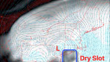
A track farther west like most of our models have would mean a beast of a storm. The question will then become how far west and whether or not any dry slot issues develop. Generally you want to be undernearth or just northwest of the mid level low pressure about 10,000 feet up - where this tracks is critical to figuring out where the heaviest snow band will be. For example the NAM, pictured above, keeps the 700mb low to our west and then sort of develops it overhead Tuesday afternoon. This would favor heaviest snow totals in the Northwest Hills and Berkshires, effectively shut off the heavy snow quickly after 3 p.m. as dry air races in aloft, and introduce mixing/precipitation type issues in southeastern Connecticut.
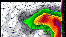
The midday European model, however, has a classic mid level low track which would ensure epic snow totals over 20" in many areas. Additionally, powerful winds would develop Tuesday afternoon as the low strengthens extremely rapidly just southeast of us. At this point, based on the pattern and a lot of the guidance, we're leaning toward the Euro with some consideration for the lesser models.
Local


I'm very confident we're going to have a big storm - the question right now is how big. Are 10"-14" common or are we closer to the upper bounds? This has the potential to be extremely impressive so stay tuned!
