
The cold air that started the weekend is starting to moderate across the state. Highs on Saturday did not make it out of the 30s in many parts of the state.
The high temperature at Windsor Locks made it up for 42 degrees. The average high for this time of year is 54 degrees.
Milder air will continue into Monday before a serious blast of cold air moves in for Tuesday.
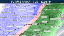
A strong cold front will bring rain to the state during Tuesday morning. As the cold air moves in, the rain will change to snow from west to east.
There could be a coating of up to an inch of snow (hills may see up to 2” amounts).
The changeover to snow along with dropping temperatures could cause slippery travel for Tuesday afternoon and Tuesday evening.
Bitterly cold air and wind will combine for dangerously coldwind chills in the single digits by Wednesday morning.
Local


Wind chills will remain in the teens for most of Wednesday before some moderation in temperature at the end of the week.
