
If you love winter weather - draw the shades and go into a 10+ day hibernation. The pattern looks pretty hideous for people who like cold and snow for the 10-14 days.
This morning temperatures have climbed into the 50s in many areas with our few inches of snow vaporized overnight. A combination of high dew points and gusty winds resulted in a dramatic loss in snowpack across the region. Here's my sad dead Christmas tree on a dirty snow pile in my front yard.
Looking forward besides a dip in temperatures over the weekend the weather pattern is going to turn quite warm. In fact, if you were to look at the forecast weather maps for next week without a date and timestamp you'd think it was a map for early spring!
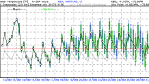
So what's the cause? A large dip in the jet stream over Alaska and northern Pacific Ocean will allow warm pacific air across the northern hemisphere. The jet stream retreats far to the north resulting in very large positive temperature anomalies across central and eastern Canada and the U.S. Locally, you can see that with this GFS ensemble temperature trend over the next 16 days with virtually all the ensemble members above climatology.
In the winter you can never rule out a wintry storm to sneak up on southern New England even in an otherwise warm pattern but it's not looking good - especially outside of the hills or inland areas with no source of cold air to the north.
