
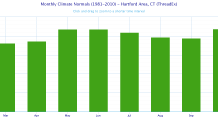
Another day with another mainly dry extended forecast - no surprise here! Sure we'll get a little rain Thursday afternoon but certainly not a drought buster! Through yesterday the Hartford area is 18.33" below average since January 1st, 2015! That is a sizable rainfall deficit and something we only see every 10 or 20 years.
That said, Over the last month drought conditions improved significantly in eastern Connecticut with over 8 inches of rain in some towns! The rest of the state the story was more of the same with well below normal precipitation. I expect the updated drought monitor tomorrow to reflect that with a downgrade of the drought conditions along the I-395 corridor.
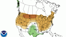
The updated 8-14 day precipitation forecast from the National Weather Service shows decent odds of below normal precipitation across the northeast in week 2. The GFS Ensembles (An snsemble is a somewhat lower resolution of a typical model that is run multipletimes with slightly different initial conditions and model physics to represent a reasonable spread of possible outcomes) show the dry pattern quite well. Of the 21 ensemble members only about 30 percent show over 1" of rain in the next 16 days!
My concern going forward is that we've wasted what is typically our wettest period of the year - October - without solid rains over a good chunk of the region. These things can change quickly but right now through there's no signal for big rains through the middle of the month.
Get the full forecast here.
Local
Connect with me on Facebook and Twitter!
