
To get severe thunderstorms you generally need two ingredients: instability and wind shear. The magnitude of both roughly correlates to the possible intensity of thunderstorms.
By Tuesday afternoon a cold front will sink to the south and ahead of it will be a favorable juxtaposition of shear and instability for severe storms. These graphs show instability and shear forecasts for Bradley Airport - and you can see both spike significantly in the afternoon on Tuesday.
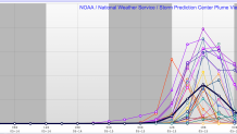
Forecast instability (CAPE) by the 21-member SREF.
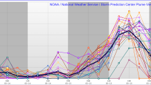
Forecast effective bulk shear by the 21-member SREF. Enough vertical wind shear is necessary to organize thunderstorms and can lead to supercells (rotating thunderstorms).
48 hours out there can be a lot of changes. This isn't a slam dunk as forecast thunderstorm development and severity is a challenge! There are a few things I'll be watching over the next day or so.
- Where does the front set up? Will the front be pushed farther south than currently expected. This could put us on the cooler and stable side of the boundary.
- Will there be morning storms or rain that prevent enough solar insolation and thereby limit instability?
- How much instability will there be? The key to this is getting enough low level moisture (high humidity near the ground) coupled with a rapid temperature drop with height above our heads.
Tuesday is worth watching with the potential for strong thunderstorms - patricularly west of I-91. We'll keep you posted!
