
This morning I measured 2.0" of sleet here in West Hartford. With a bit of rain added in the sleeted melted down to 1.05" of liquid - weight-wise it was about the equivalent of 10 or 11" of snow!
For days we have been talking about the sleet and along the I-84 corridor the sleet managed to pile up more than the 1" we expected as the change to rain took forever to arrive here in West Hartford. So what cause all this sleet?
We get sleet as snowflakes fall from the clouds and melt due to a layer of air that's over 32 degrees aloft. As the melted snowflake falls lower to the ground it encounters air that is below 32 degrees below the warm layer causing it to refreeze. The layer of cold air has to be cold enough and thick enough to get the liquid drop to refreeze.
This is harder to forecast than it sounds! For example, the warm layer really shouldn't be too warm. If it's over 3C the snowflakes completely melt which makes it harder for the drop to refreeze. Also, the cold layer needs to be deep enough and cold enough to get a refreeze to happen (a thousand feet of 31F isn't going to cut it). Oh yeah and on top of that it can't be too warm near the ground so the sleet pellets start melting again.
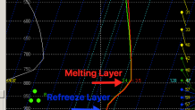
Our models were pretty different with how the atmosphere's thermal profile would look - particularly around Hartford. This sounding valid at 10 p.m. is a 3 hour forecast off the High Resolution Rapid Refresh Model.
The warm layer is around +3.5C which would signal a change to rain as the drops would be ice free and have a hard time refreezing. As it turned out the actual warm layer around that time was closer to +2C. These are really tiny differences in the temperature structure of the atmosphere that have a huge difference in the final outcome. All of our high resolution models played catch up all day and all evening limiting the warmth in that warm layer.
Local
In the end I'm pretty pleased with the forecast - though it wasn't perfect. We were more bullish with the sleet and wintry weather potential than anyone else in the market and even the typically bullish National Weather Service leading up to the event. The storm produced more sleet than I expected around Hartford given the very delayed transition to rain. Out east and along the coast, things worked out quite well with warmer temperatures in that warm layer and warmer near ground temperatures resulting in mainly rain as far north as Killingly. The possible change to snow in Litchfield County we thought was a possibility did not occur so they wound up on the low end of our very large 2"-6" range that allowed for that possibility.
Onto the next one!
