
A wind-driven sleet across the state this evening. Hideous. Temperatures are generally above freezing so we're expecting roads will be a bit slushy inland but with the exception of the hills they should not freeze up. Along the shoreline we'll see mainly rain besides a few sleet pellets.
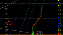
The reason for sleet is that we have warm air in the clouds causing snow flakes to at least partially melt with a cold pocket of air around 3,000 feet above our heads. That causes the partially melted snow flake to refreeze into an ice pellet! This sounding off one of our computer models for this evening in Windsor Locks shows a classic sleet setup. A warm layer of about +2C about 7,000 feet above our heads with a deeper subfreezing layer about 2,500 feet above our heads near -4C.
The accumulation forecast is a real pain. 1" of liquid rain generally produces about 10" of snow - but only about 3" of sleet! With that in mind getting excessive sleet accumulation is really tough to do. I do expect we'll see accumulation of around an inch on the I-84 corridor with 1"-2" in the higher elevations just northwest of there and even in parts of the Farmington Valley and Northeast Hills.
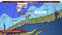
In the Litchfield Hills, there is likely to be a bit of snow that mixes in as well. We've put out an unusually large range of 2"-6" forecast for the Litchfield Hills northwest of Torrington/Winsted to account for this possible change to snow which would allow for accumulation to add up more quickly.
Strong winds will continue across the state with gusts up to about 50 mph along the shoreline. This should fall short of what I expected yesterday which is good. Also, tides are quite low today so even with 3 feet of storm surge coastal flooding will be minor.
