
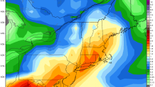
There's a few questions we're still trying to answer regarding this weekend's nor'easter. We're quite confident in 1"-2" of rain across the state with the heaviest falling Saturday evening and night. There are a few other details we need to work on.
1) Will we wind up seeing more than 2" of rain? Some of our computer models (namely the GFS) have been showing extremely heavy rainfall totals - some runs have had in excess of 4"! The GFS ensemble mean is between 1.5" and 2.0" and the Euro Ensemble mean is between 1.0" and 1.5" across the state. With very strong convergence, a powerful upper level jet streak and closing off low, along with an anomalous surge of moisture the ingredients are there for localized totals over 2".
2) When does the rain begin on Saturday? Will the storm slow down just a bit on Saturday and give us a dry morning and midday? That's a possibility and could salvage people's early Saturday plans.
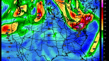
3) After the rain winds down Sunday morning (it may end as early as 8 or 9 a.m.) will we see a second round of rain in the afternoon? The GFS keeps us dry while the Euro brings in a second and powerful upper level disturbance in the afternoon. If the latter solution verified a period of heavy rain and even some thunder could redevelop Sunday afternoon. I really don't have a good sense of what is going to happen here later Sunday so stay tuned for more on that.
