
Our warm beginning to January is coming to an end. Temperatures will be around or even a bit below normal for the next week. The question is will we get any snow?
This weekend's storm is a miss. As I mentioned in my post earlier this week the weather pattern is just not favorable for a snowstorm here. Sometimes hostile patterns can deliver snow but this one will not.
By next weekend, however, it does appear the pattern begins to shift. We'll have cold air nearby and increasingly it looks like we'll be entering into a stormy regime. Both the GFS and European computer models have strong signals for storminess nearby in the Day 9 and Day 10 range.
What has been a very consistent signal toward the end of the month and early February is the potential for a blockbuster pattern. This is the kind of pattern that tends to bring prolonged cold and big snow. It's a pattern that meteorologists drool over in New England.
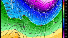
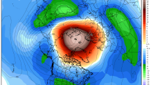
The big red blobs are areas of unusual warmth and large "blocks" in the atmosphere. The presence of the blocking over Greenland and the Arctic - when coupled with ridging over the western United States is the holy grail for Northeastern U.S. snow. These blocks tend to result in large undulations in the jet stream and are conducive to storm development off New England.
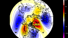
Will this verify? Of course a 3 week forecast - even when you're just looking at a general pattern - is a tough one. But there are some things that make me think that this could actually happen. The biggest signal in my mind is unusually warm air in the stratosphere (the layer of the atmosphere above the troposphere about 12 miles over our heads) that is already in place and continues to show up over the next 10 days. This stratospheric warming can be a precursor to blocking over the Arctic and Greenland as that warm signal descends and winds up disrupting the Polar Vortex. The Pacific jet stream - that has flooded the country with warmth - appears to get shuffled quite a bit in the coming weeks.
Local


If you love winter - stay tuned. I don't think our snowless stretch will continue forever. If you hate the snow you may have a rough stretch coming up. We'll keep you posted.
