
What to Know
- A significant/high-end flood event is possible in Connecticut, with a rare "high risk" for excessive rainfall issued
- 3 to 5 inches of rain with locally higher amounts expected
- Flash flooding is expected, as well as river flooding, with the heaviest rain potential between 10 p.m. Wednesday and 6 a.m. Thursday
NBC Connecticut meteorologists have issued a First Alert for flood producing, heavy rainfall in the state Wednesday night and Thursday.
The rain is the remnants of Hurricane Ida, which is now a Tropical Depression moving northeast toward New England.
The first showers will start Wednesday morning through the afternoon, but the heaviest rain will arrive Wednesday night continue into Thursday morning. The greatest potential for flooding is from 10 p.m. Wednesday to 6 a.m. Thursday.
Get Connecticut local news, weather forecasts and entertainment stories to your inbox. Sign up for NBC Connecticut newsletters.
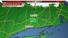
A flash flood watch has been issued for the entire state for Wednesday and Thursday.
The remnants of Ida could bring anywhere from 3 to 5 inches of rain to the state, with locally higher totals possible.
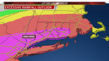
The Weather Prediction Center has issued a high risk for excessive rainfall for parts of Connecticut. It is very rare to see this threat level in Connecticut.
Since we are expecting several inches of rain, flooding will be a problem for anyone who lives in flood prone areas. Basements, roads, underpasses, small rivers and streams are all at risk of flooding.
Connecticut has seen its share of rain over the past month or so. The ground is already saturated and rivers are running high from recent rains, including what Tropical Storm Henri brought a little more than a week ago.
