
The weather will be quiet for any Easter Sunday plans with partly to mostly cloudy skies and temperatures rising into the middle to upper 50s.
A strong storm system will track towards Connecticut Sunday into Monday. Rain will overspread the state Monday morning with winds picking up as well.
A High Wind Watch has been posted for all of Connecticut.
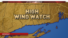
Winds could gust over 60 mph in parts of the state. We're currently forecasting peak wind gusts of 55 to 65 mph. There is some indication that winds could gust even higher than that.
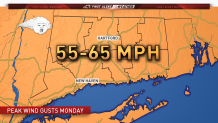
Damage typically occurs when winds start to gust over 57 mph, so this is a storm system that we will continue to monitor very closely.

What will be creating the strong winds is a very powerful low level jet. The biggest question is do some of those winds from the low level jet mix down to the surface? It appears at least some of them will but how much? As we said above we expect winds of 55 to 65 mph however if enough mixing occurs we could see gusts as high as 75 to even 80 mph in parts of the state.
We will continue to monitor the latest data and provide updates to the forecast as needed.
