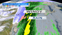
The NBC Connecticut meteorologists have issued a First Alert for a windswept rainstorm that will arrive Christmas Eve and continue into Christmas Day.
The strong storm system will bring with it heavy rain and potentially damaging winds. The heaviest rain will fall overnight on Christmas Eve and taper off by Christmas morning.
The area of low pressure will cut to the west of Connecticut meaning we will be on the warm side of the storm. Temperatures will be in the mid 50s for Christmas Eve and low 60s for Christmas Day!
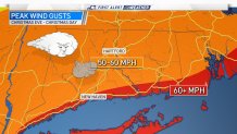
The main concern with this storm is the threat for damaging winds. Some of our computer guidance suggests winds could gust over 50 mph early Christmas morning.
In addition to the wind heavy rainfall is another concern. It appears over 2 inches of rain could fall in parts of Connecticut. With the warm temperatures, snow will not be an issue with this storm.
With mild temperatures and significant rainfall, we'll have to watch the potential for rapid snow melt and potential flooding.
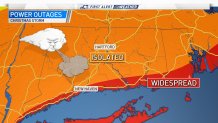
The chance for power outages is largely isolated through most of the state since with the winter season, there are not leaves on the trees to cause the same outage issues as during the summer months.
Before the storm the next few days are fairly quiet with a blend of sunshine and clouds and cool temperatures.