
An exceptional thunderstorm in the greater New Haven area produced an EF-1 tornado in Bethany, Hamden, and North Haven followed by a remarkable area of powerful straight line winds in North Branford, East Haven, Branford, and the Leetes Island section of Guilford. The storm reminded me quite a bit of the 2018 tornado event a bit farther to the west.
The tornado was on the ground for 11.1 miles from the eastern part of Bethany, through Hamden, and into the Montowese section of North Haven. The 11.1 mile path was continuous and was the longest tornado path length in Connecticut since the Windsor Locks F4 tornado of 1979.

The storm was well forecast. The cluster of thunderstorms that produced the worst damage developed along a warm front where an area of modest instability was juxtaposed with strong low level wind shear. We had mentioned the possibility for tornadoes several days in advance and the day prior to the Storm Prediction Center put us in an "enhanced" risk for severe thunderstorms.

As the storms developed, temperatures ranged from nearly 90 degrees in Greenwich to in the low 60s in Windsor Locks. A warm front that moved through in the late morning and midday was beginning to sink south as a cold front.
There was a plume of steep mid level lapse rates over southern Connecticut (mid level lapse rates 700-500mb) which helps maximize instability as it shows temperatures decreasing rapidly with height. Mixed-Layer CAPE values were close to 1,000 j/kg.

Along the front there was significant low level wind shear present with effective Storm Relative Helicity of nearly 300 m2/s2. Deep layer effective shear was close to 60 knots! This allowed storms to rotate and the strong low level shear ensured that strong rotation was possible in the lowest levels of the atmosphere.

There was a storm merger over Waterbury which gave a boost to the storm cluster that moved toward New Haven. Velocity data showed powerful winds in excess of 70 mph over Prospect and Bethany around 3:45 p.m. The winds picked up more as the storm moved through Bethany as a tornado developed.

Radar showed lofted tornado debris at 3:55 p.m. over Bethany as a circulation developed. The area of rotation strengthened into Hamden and North Haven when the tornado reached its peak intensity of near 110 mph and it was about 1/3 of a mile wide. The Tornado Debris Signature continued until 4:00 p.m.

While the Tornado Debris Signature was subtle, the reflectivity signature was classic for a tornado. The tornado developed just south of the "notch" on reflectivity.

Effectively a small area of no precipitation developed north of the tornado in what we call an inflow notch. Thankfully we located this on radar before the tornado touched down, and when coupled with a strengthening velocity signature, we were able to give a timely warning to people in the path of the storm.

Beyond North Haven the damage swath broadened as the rotation weakened. Even so, Doppler Radar detected winds close to 100 mph over Branford and North Branford. In fact the winds here were just as strong as the tornado in many places!
As the tornadic circulation occluded and retreated toward the rear of the storm what is known as a Rear Flank Downdraft produced a large swath of destruction in Branford, East Haven, and North Branford.

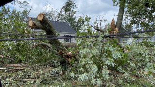
The damage in this part of the state was the worst they've seen since July 10, 1989 and the historic tornado. The damage swath was nearly continuous from Bethany to Guilford and seemed to me to be more impressive than the 2018 event.
