Some people woke up to a fresh coating of May snow on Saturday morning. Early this morning, rain changed to snow and accumulated up to and over a 1/2" in some locations. Up to .75" of snow was reported in parts of Tolland county.
Photos: May Snow For Parts of the State
More snow and rain showers are expected through the day today as an unseasonably cold air mass moves into the state.
High temperatures today will average 25 degrees below average. Wind chill values will generally stay into the 20's in the hills with 30's elsewhere. The average high temperature for May 9 is 69 degrees.
A wind advisory has also been posted for northern Connecticut as winds will gust over 40 mph at times.
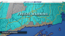
A freeze warning has been posted for most of the state for Sunday morning. Exceptions include the shoreline where temperatures will remain above freezing and northern Litchfield County where the growing season has not officially started.
Temperatures will moderate for Mother's Day on Sunday. Highs will be 10 degrees warmer in the upper 50's. The wind will continue through the rest of the weekend.