After temperatures reached the 60s Wednesday, a wintry mix is expected to move in Friday.
The NBC Connecticut First Alert weather team has issued a First Alert for the anticipated snow and sleet.
A cold front moved across New England Wednesday, quickly dropping temps and bringing back a colder air mass for the end of the week.
Get Connecticut local news, weather forecasts and entertainment stories to your inbox. Sign up for NBC Connecticut newsletters.
Low pressure will ride along a front Thursday night into the day on Friday. This provides the energy and moisture (while locking in the cold air from the north thanks to counter-clockwise airflow) for us to see snow.
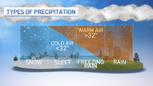
Computer models agree that we start as snow and then change over to a wintry mix. We could transition from a mix back to snow before the system pulls far enough away later on Friday.
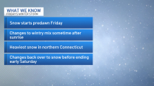
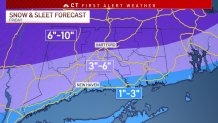
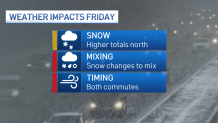
The chance for accumulating snow has been pretty consistent since the weekend. The highest snow totals look like they'll set up in northern Connecticut. With the changeover to wintry mix, sleet may mix in with snow, making it tough to shovel.
Local

Everyone across the state will see wintry weather through much of the day on Friday, however - including the morning AND evening commutes. It looks like the morning commute will be hit harder than the evening. Travel through the day will be tricky.
The question of timing for precipitation changeover (from snow to mix and back to snow) still needs to be nailed down. We're also keeping an eye on how far north the mixing will occur. Any mixing knocks down snow totals. Depending on how far north the center of the storm goes, we might also see some rain along the shoreline.