
An anomalously cold air mass with dip down from the northern latitudes by the end of the week.
The airmass will bring well below normal temperatures coupled with snow that could accumulate in parts of the state.
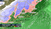
Take a look at the European forecast model which shows rain transitioning to snow in the elevated areas of northwest Connecticut Friday night into Saturday morning.
The coolest part of the airmass moves through Saturday afternoon which will result in strong gusty winds and periods of rain, snow, and graupel statewide.
Temperatures at 18,000 feet will be nearly -40 degrees Fahrenheit.
With strong gusty winds Saturday afternoon wind chill values will be quite low for this time of year. Wind chills will range from the upper 20s to the middle 30s.
Stay with the NBC Connecticut First Alert Weather Team for updates.
