
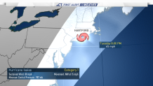
The NBC Connecticut First Alert Weather team has issued a First Alert for impacts from Hurricane Isaias in New England next Tuesday into Wednesday.
The U.S. National Hurricane Center said Isaias could hit Connecticut Tuesday night into Wednesday morning.
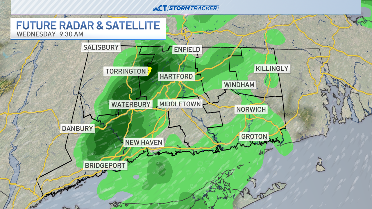
Isaias could potentially bring strong winds, inland flooding and storm surge to Connecticut, depending on the storm track, according to Chief Meteorologist Ryan Hanrahan. Heavy rain is likely across New England.
Hurricane Isaias is expected to brush the coast of Florida, move north into the Carolinas before continuing north towards New England.
"The storm crosses New England as a tropical storm - heavy rain the main threat but strong wind/storm surge issues still possible," Ryan tweeted.
The American Red Cross issued a warning urging everyone in the path of Isaias to get ready for any impacts here in New England.
“Just as the American Red Cross prepares for disasters, it’s important for people to prepare before severe weather hits,” said Mario Bruno, CEO, American Red Cross Connecticut and Rhode Island Region, said in a statement. “People across Connecticut should get ready for the potential impact of Isaias now and because of COVID-19, getting prepared will look a little different than in other years.”
Forecasters declared a hurricane watch for parts of the Florida coastline on Friday as Hurricane Isaias drenched the Bahamas on a track for the U.S. East Coast.
Isaias had maximum sustained winds of 75 mph (120 kph) Friday afternoon and was expected to remain a hurricane for the next few days, according to the U.S. National Hurricane Center in Miami. It was centered about 245 miles (395 kilometers) southeast of Nassau in the Bahamas and was moving northwest at 16 mph (26 kph).
The Hurricane Center said heavy rains associated with the storm “may begin to affect South and east-Central Florida beginning late Friday night, and the eastern Carolinas by early next week, potentially resulting in isolated flash and urban flooding, especially in low-lying and poorly drained areas.”
A hurricane warning was in effect for Andros Island, New Providence, Eleuthera, Abacos Islands, Berry Islands, Grand Bahama, Bimini, Acklins, Crooked Island, Long Cay, the Inaguas, Mayaguana, Ragged Islands, Cat Island, the Exumas, Long Island, Rum Cay, and San Salvador.
Two of those islands, Abaco and Grand Bahama, were battered by Dorian, a Category 5 storm that hovered over the area for two days and killed at least 70 people, with more than 280 reported missing. People are still living in tents on both islands, and officials said crews were trying to remove leftover debris ahead of Isaias.
On Thursday, while still a tropical storm, Isaias toppled trees, destroyed crops and caused widespread flooding and small landslides in the Dominican Republic and Puerto Rico, where hundreds of thousands of people were left without power and water.
Officials reported that a man died in the Dominican Republic when he was electrocuted by a fallen electrical cable.
The Puerto Rico National Guard rescued at least 35 people from floodwaters, which swept away one woman who remains missing.
Isaias was expected to produce 4 to 8 inches (10 to 20 centimeters) of rain in the Bahamas and the Turks and Caicos Islands.
BULLETIN
Hurricane Isaias Advisory Number  15
NWS National Hurricane Center Miami FL       AL092020
500 PM EDT Fri Jul 31 2020

...HURRICANE WARNING ISSUED FOR PORTIONS OF THE FLORIDA EAST
COAST...
...TROPICAL STORM CONDITIONS AND HEAVY RAINS CONTINUE TO SPREAD
ACROSS THE CENTRAL BAHAMAS...


SUMMARY OF 500 PM EDT...2100 UTC...INFORMATION
----------------------------------------------
LOCATION...22.6N 75.7W
ABOUT 195 MI...320 KM SSE OF NASSAU
ABOUT 330 MI...535 KM SE OF FREEPORT GRAND BAHAMA ISLAND
MAXIMUM SUSTAINED WINDS...75 MPH...120 KM/H
PRESENT MOVEMENT...NW OR 305 DEGREES AT 15 MPH...24 KM/H
MINIMUM CENTRAL PRESSURE...991 MB...29.27 INCHES


WATCHES AND WARNINGS
--------------------
CHANGES WITH THIS ADVISORY:

A Hurricane Warning is in effect for the east coast of Florida from
Boca Raton to the Volusia/Brevard County Line.

A Hurricane Watch is in effect from the Volusia/Brevard County Line
to the Flagler/Volusia County Line and from south of Boca Raton to
Hallendale Beach.

A Storm Surge Watch is in effect for the east coast of Florida from
Jupiter Inlet to Ponte Vedre Beach.

A Tropical Storm Watch is in effect from the Flagler/Volusia County
Line to Ponte Vedre Beach.

A Tropical Storm Warning is in effect for Lake Okeechobee.

SUMMARY OF WATCHES AND WARNINGS IN EFFECT:

A Hurricane Warning is in effect for...
* Boca Raton to the Volusia/Brevard County Line Florida
* Northwestern Bahamas
* Southeastern Bahamas
* Central Bahamas

A Hurricane Watch is in effect for...
* Hallendale Beach to south of Boca Raton Florida
* Volusia-Brevard County Line to the Flagler/Volusia County Line

A Storm Surge Watch is in effect for...
* Jupiter Inlet to Ponte Vedre Beach Florida

A Tropical Storm Warning is in effect for...
* Turks and Caicos Islands
* North of Ocean Reef to south of Boca Raton Florida
* Lake Okeechobee

A Tropical Storm Watch is in effect for...
* Flagler/Volusia County Line to Ponte Vedre Beach Florida

Interests elsewhere along the southeast coast of the United States
should monitor the progress of Isaias.  Additional watches or
warnings may be required later tonight and Saturday.

A Hurricane Warning means that hurricane conditions are expected
somewhere within the warning area. A warning is typically issued
36 hours before the anticipated first occurrence of
tropical-storm-force winds, conditions that make outside
preparations difficult or dangerous.  Preparations to protect life
and property should be rushed to completion.

A Hurricane Watch means that hurricane conditions are possible
within the watch area.  A watch is typically issued 48 hours
before the anticipated first occurrence of tropical-storm-force
winds, conditions that make outside preparations difficult or
dangerous.

A Storm Surge Watch means there is a possibility of life-
threatening inundation, from rising water moving inland from the
coastline, in the indicated locations during the next 48 hours.
For a depiction of areas at risk, please see the National Weather
Service Storm Surge Watch/Warning Graphic, available at
hurricanes.gov.

A Tropical Storm Warning means that tropical storm conditions are
expected somewhere within the warning area within 36 hours.

A Tropical Storm Watch means that tropical storm conditions are
possible within the watch area, generally within 48 hours.

For storm information specific to your area in the United
States, including possible inland watches and warnings, please
monitor products issued by your local National Weather Service
forecast office. For storm information specific to your area
outside of the United States, please monitor products issued by
your national meteorological service.


DISCUSSION AND OUTLOOK
----------------------
At 500 PM EDT (2100 UTC), the center of Hurricane Isaias was located
by satellite imagery and Bahamas radar data near latitude 22.6
North, longitude 75.7 West. Isaias is moving toward the northwest
near 15 mph (24 km/h), and a general northwestward motion with some
decrease in forward speed is expected for the next day or so,
followed by a turn toward the north-northwest by late Sunday.  On
the forecast track, the center of Isaias will continue to move near
or over the Southeastern Bahamas this afternoon and evening. Isaias
is forecast to be near the Central Bahamas tonight, and move near or
over the Northwestern Bahamas Saturday and near the east coast of
the Florida peninsula Saturday afternoon through Sunday.

Maximum sustained winds are near 75 mph (120 km/h) with higher
gusts.  Strengthening is expected later tonight and early Saturday,
and Isaias is forecast to remain a hurricane for the next couple of
days.

Hurricane-force winds extend outward up to 35 miles (55 km) from the
center and tropical-storm-force winds extend outward up to 175 miles
(280 km).  A private weather observing station at Pitts Town Point,
Bahamas, recently reported a sustained wind of 37 mph (59 km/h).

The estimated minimum central pressure is 991 mb (29.27 inches).


HAZARDS AFFECTING LAND
----------------------
Key messages for Isaias can be found in the Tropical Cyclone
Discussion under AWIPS header MIATCDAT4, WMO header WTNT44 KNHC, and
on the web at www.hurricanes.gov/text/MIATCDAT4.shtml.

STORM SURGE:  The combination of a dangerous storm surge and the
tide will cause normally dry areas near the coast to be flooded by
rising waters moving inland from the shoreline.  The water could
reach the following heights above ground somewhere in the indicated
areas if the peak surge occurs at the time of high tide...

Jupiter Inlet to Ponte Vedra Beach FL...2-4 ft
North Miami Beach to Jupiter Inlet FL...1-3 ft

The deepest water will occur along the immediate coast near and to
the right of the center, where the surge will be accompanied by
large waves.  Surge-related flooding depends on the relative timing
of the surge and the tidal cycle, and can vary greatly over short
distances.  For information specific to your area, please see
products issued by your local National Weather Service forecast
office.

A dangerous storm surge will raise water levels by as
much as 3 to 5 feet above normal tide levels in areas of onshore
winds in the Bahamas.

WIND:  Hurricane conditions will continue to spread northwestward
into the central and northwestern Bahamas tonight and Saturday.

Hurricane conditions are expected to reach the coast within the
hurricane warning area in Florida late Saturday and Saturday night.
Winds are expected to first reach tropical storm strength on
Saturday, making outside preparations difficult or dangerous.
Preparations to protect life and property should be rushed to
completion.

RAINFALL: Isaias is expected to produce the following rain
accumulations:

Bahamas, Turks and Caicos: 4 to 8 inches.

Cuba: 1 to 2 inches, with isolated maximum totals of 4 inches.

These rainfall amounts could lead to life-threatening flash  and
urban flooding, especially in low-lying and poorly drained areas.

From Friday night through Tuesday:

South Florida into east-Central Florida: 2 to 4 inches, with
isolated maximum totals of 6 inches.

Northeast Florida into coastal Georgia: 1 to 2 inches.

Carolinas into the mid Atlantic, including the southern and central
Appalachians: 2 to 4 inches, with isolated maximum totals of 6
inches.

Heavy rainfall from Isaias could result in isolated flash and urban
flooding, especially in low-lying and poorly drained areas. Isolated
minor river flooding is possible across the eastern Carolinas and
into Virginia.

SURF:  Swells generated by Isaias are affecting portions of
Hispaniola, eastern Cuba, the Turks and Caicos, and the southeastern
and central Bahamas. These swells will spread along the east coast
of Florida and the southeastern United States coast on Saturday.
These swells are likely to cause life-threatening surf and rip
current conditions. Please consult products from your local
weather office.


NEXT ADVISORY
-------------
Next intermediate advisory at 800 PM EDT.
Next complete advisory at 1100 PM EDT.

$$
