A major nor'easter will develop off the coast of New England this weekend but it will be the storm's track that will determine how much snow we see in Connecticut.
Some computer models Wednesday showed a slight move east in the track of the storm on Saturday.
A winter storm watch has been issued for Fairfield, New Haven, Middlesex, New London, Tolland, and Windham counties.
Get Connecticut local news, weather forecasts and entertainment stories to your inbox. Sign up for NBC Connecticut newsletters.
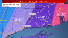
The storm appears it will pass close enough to us to bring 6" to 12" of snow to eastern Connecticut. Areas west of I-91 could see anywhere from 3" to 6" of snow.
That track of the storm makes it less likely for us to see blizzard conditions in Connecticut, but still brings accumulating snow and gusty winds to the state.
A shift east or west in the track would mean different implications for us here in Connecticut. If the track moves west and closer to land, that increases our chance for a bigger and more impactful storm.
The snow will start around daybreak Saturday, but we would see the heaviest snow through the early afternoon. Snow wraps up Saturday evening into early Sunday.
If you have plans this weekend, you'll want to continue checking in with our meteorologists on-air, on our website, and on social media.