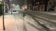
Snow started falling just before noon Tuesday, and while it won't accumulate to much the combination of snow, sleet and freezing rain could make for tricky travel Tuesday night and into Wednesday morning.
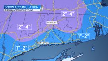
A light wintry mix continues through tonight with some sleet, freezing rain, and snow. An additional coating to an inch of snow is expected to accumulate. A Winter Weather Advisory remains in effect.
Temperatures will remain near or below freezing, leaving the potential for icy roads. As of 8 p.m., AAA Hartford had responded to more than 800 calls for emergency roadside service.
Some school districts have announced remote learning days or delays for Wednesday.
Occasional snow showers are expected Wednesday but overall little accumulation is expected.
Cold temperatures will stick around, with high temperatures between 15 and 20 on Friday and wind chills below zero Friday night.