
A strong storm system will track up the east coast and result in many impacts here in Connecticut. The latest track has the storm staying to the west of Connecticut which will ultimately usher in some milder air and result in a transition from snow to sleet and eventually over to plain rain.
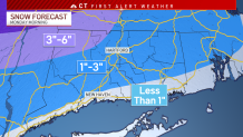
A brief period of snow will be seen at the onset of the storm before the quick transition to plain rain. The most snowfall will be seen in northwest Connecticut where 3 to 6 inches of snow could fall before the transition over to rain there as well.
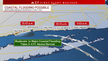
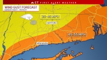
Two additional impacts are coastal flooding and strong winds.
Get Connecticut local news, weather forecasts and entertainment stories to your inbox. Sign up for NBC Connecticut newsletters.
An astronomical high tide coupled with a strong southeast wind could result in moderate to major coastal flooding for our shoreline communities. High tide will occur between 9 a.m. and 11 a.m. and latest guidance suggests tide could rise to 3 to 4 feet above normal.
A winter storm watch has been issued for northern Litchfield County.
As the system pulls through the region, strong gusty wind will be experienced with gusts to 55 mph expected along the shoreline.
The precipitation will mostly come to an end by 10 a.m. on Monday.
