
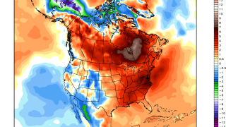
It's been an exceptionally mild winter across New England so far and there's no real sign of any change over the next week. It's not just New England that's been warm - record warmth has been occurring throughout the Northern Hemisphere including parts of Europe and Asia (with the exception of Alaska).
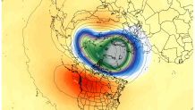
So where's the cold? An unusually strong and stable polar vortex has remained undisturbed through most of the winter. Way up in the stratosphere this whirlpool of cold air has been remarkably resilient and has effectively kept the cold bottled up over the Arctic. Above you can see the the unusually cold air in the stratosphere over Greenland and the Arctic Ocean about 70,000 feet above the ground. Arctic outbreaks tend to occur when the polar vortex gets disturbed
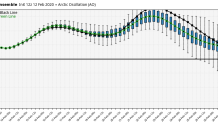
So what's happening closer to the ground? We like to look at something called the Arctic Oscillation or AO which helps quantify the jet stream pattern up over the Arctic. When the AO is negative cold air can get dislodged from the Arctic with a wavy jet stream. When the AO is positive cold air generally remains trapped up north.
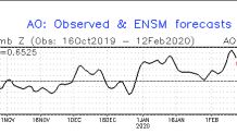
Since January 1st the Arctic Oscillation has been strongly positive. It's no surprise our winter has been so mild. How's the forecast look? More strongly positive values and a likely milder than normal weather regime for us.
The strong and stable polar vortex is related to the strongly positive Arctic Oscillation. All of that has worked to create a fairly hostile pattern for cold shots and snow here locally. At least for the time being that doesn't show signs of changing. The issues in the Arctic coupled with the background warming due to human caused climate change has come together to create a perfect storm of warmth for many.

We'll see if winter can make a comeback in March - Stay Tuned!
