
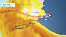
NBC Connecticut's team of meteorologists is watching a storm chance that begins late on Monday into Tuesday. A few storms develop later Monday night ahead of an approaching front/low pressure area.
We're watching the storms out ahead of the warm front that's expected to lift north, and another area of storms associated with a cold front in the afternoon.
We are under a level 1 risk for severe weather. While every storm will not become severe, a few may strengthen so be sure you have a way to get alerts if you're sleeping.
Get Connecticut local news, weather forecasts and entertainment stories to your inbox. Sign up for NBC Connecticut newsletters.
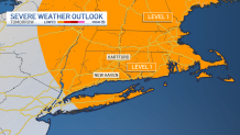
Heavy rain and gusty winds are expected with any storms. There is also the low risk for a tornado to develop.
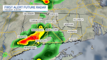
A few more storms are possible in the afternoon.
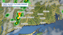
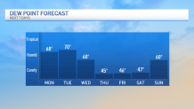
Once the cold front moves through, expect more of a fall-like feel to the air. Lower dew points and cooler temps settle in for the late week along with sunshine returning for a few days.
You can get the latest forecast anytime here.
Local


Be prepared for your day and week ahead. Sign up for our weather newsletter.
