
Evening Update: No big changes to the forecast though I have lowered the accumulation forecast for central Connecticut to 1"-2" and 2"-5" in the far northern part of the state. While we won't pick up much accumulation we're going to have to watch temperatures closely tomorrow morning as a burst of heavier precipitation comes in.
The HRRR model insists on temepratures remaining quite cold in the lowest few hundred feet of the atmosphere which would result in a period of heavier freezing frain - creating a glaze on any untreated surface. The east slopes of the Litchfield Hills and the Connecticut River Valley around and just north of Hartford would be most suscepitable to this.
Morning Update: After a cold morning across Connecticut we'll see flakes in the air by the evening across Connecticut. This storm isn't going to produce a lot of snow but it is going to be messy later this evening and especially early tomorrow morning.

The storm is going to come in two parts - and there may even be a brief break or lull in between. The first part is this evening. Snow will overspread all of Connecticut - even down to the beaches - and a minor fluffy accumulation of an inch (maybe 2) is expected. The snow will not be heavy but it will be steady. One reason we're expecting accumulation from just a minor amount of precipitation will be the efficiency of snowflake production.
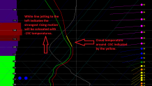
This is a temperature sounding off one of our computer models for New Haven valid around 10 p.m. this evening. A few things to note. One is that temperatures are below freezing from the ground all the way up through the clouds - that means no melting. The second is that most of the lift is occuring where temperatures are around -15C. Why does this matter? This is the temperature where snowflakes form the most effiiciently AND the favored snowflake is a dendrite. These tend to pile up quickly - think "fluff factor". That's what we'll have this evening even down to the shoreline. While it's not the most likely scenario - I can't rule out an inch or two even down to the beaches.
After midnight we get a brief break before the brunt of the storm moves in. As it does warm air will be flooding north as well - first a few thousand feet above our heads and more slowly near the ground (with the exception of the coast - where every layer warms quickly). The reason the cold is not going to hang tough is because we don't really have a well positioned high pressure to the north to deliver a steady supply of cold and dry air. There were a few computer model runs on Thursday that showed this - but since then that feature has gone away with the high really scooting to the east of us. This will make it easier for southerly flow to develop and bring in the warmth.
The question will be how quickly does it warm up? This is key for the morning commute. In these scenarios the Connecticut River Valley near and north of Hartford can rot around 32F for a while before the cold that's trapped in the valley can mix out. Initially, I think we'll see a period of snow and/or freezing rain when round 2 develops prior to dawn that quickly flips to all freezing rain and eventually rain. By 7 a..m I expect Hartford to be close to or above freezing while the suburbs north and west of the city remain just below.
Local


So the bottom line is we get some snow this evening... and then inland areas get a predawn burst of wintry mix. By the morning commute we'll be all rain south of I-84 and the valley around and north of Hartford will be transitioning quickly from freezing rain to rain. This won't be an "ice storm" but temperatures near or below 32F will keep things slick and slushy around daybreak. By mid-morning roads should be fine as temperatures soar into the middle 40s for most locations melting whatever we had.
More to come later!
