
Two storms each dropping 1"-2" of rain - finally! Combined with snow melt to our north this rain may even be enough to result in minor flooding on some of the larger rivers in the state.
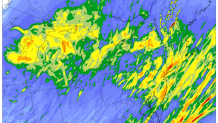
The heaviest rain tomorrow will fall during the morning commute with occasional rain during the midday and afternoon hours. A few thunderstorms are possible tomorrow along with any heavier downpours that develop.
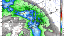
One of the things we'll have to watch tomorrow is a localized are of heavy rain in southern Connecticut with strong onshore flow. Some of the NCAR ensemble members show a localized band of 3" of rain near the Merritt Parkway. This is a phenomenon that has been documented before (Colle and Yuter, 2007) as southerly flow over the ocean is slowed by friction over Long Island and Connecticut resulting in convergence - in addition to increase lift forced as air is forced up and over the small hills on Long Island and Connecticut. A local minima in precipitation is observed over Long Island Sound.
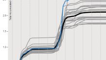
Another storm approaches on Thursday and that may result in even more rain. The GFS model shows very good odds of over 2" of rain in Hartford by the time the Thursday storm is over (each line represents a different computer model precipitation forecast) and other models have even more rain.
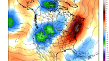
If the rain gets you down - don't worry. There is a strong signal for above normal temperatures next week as a southwesterly wind flow develops and warm air moves toward New England.
Right now we're forecasting 70F on Tuesday. Who's excited?
