
Heavy rain and gusty winds are expected to carry on overnight, winding down by daybreak.
There were reports of minor coastal flooding in Milford and Guilford on Wednesday afternoon because of the unusually high tide and heavy, but the much-needed rainfall that hit the state is expected to continue into early Thursday.
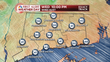
The rain was heavy in spots during the evening commute, so NBC Connecticut has declared a First Alert Weather day.
Connecticut could see as much as one-and-a-half to three inches of rain, with the western hills in the state seeing the brunt of it.
The rain is expected to fall heavily into pre-dawn on Thursday.
Exact Track
Winds were expected to reach gusts of 40 to 50 miles per hour overnight. With leaves still on the trees, there still is a concern that the winds could bring down some branches and cause scattered power outages.
As of 10:53 p.m., Eversource reported 1,795 power outages, including 561 in Lyme, 338 in Montville, 337 in Nowalk and 124 in East Haddam. There were scattered outages in several other communities as well. Wethersfield had over 700 power outages at one point in the evening.
While there can be a shower early Thursday, much of the day features clearing with mild temperatures ranging from 70 to 75 degrees before colder air moves in.
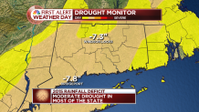
No doubt, the rain is needed. The 2015 rainfall deficit at both Windsor Locks and Bridgeport is more than 7 inches. Most of the state is in a moderate drought.
It will be breezy on Thursday and Friday. But that's a sign of high pressure building in, and indeed it will.
Local


The start of the weekend looks great. Temperatures will be in the 50s on Halloween afternoon, but fall back pretty quickly through the 40s in the evening. It will likely be dry but chilly.
Don't forget to set clocks back before bed Saturday night. Daylight Saving Time begins at 2 a.m. Sunday.
Sunday's still a toss up at this point. Northern and southern stream systems approach, but should remain separate. It looks like moisture gets pulled north into the northern system, but it may sneak by to the north of Connecticut without much impact.
For now, the forecast is for mostly cloudy skies with the chance for showers on Sunday and Monday.
[HAR] Storm Photos
Though October is winding down and November is almost here, no sign of a cool down exists.
In fact, the trend for the first week of November is warming. Indications show a much above average air mass moving in, meaning temperatures could return to the middle and upper 60s next week!
Click here for the "Fearless Forecast" for next week.
