
Weather Twitter lit up over the last 24 hours with some absurdly warm air expected to overspread the northeastern United States early next week. There are a few ways to look at this. For one, check out the 10 day European model high/low forecast for Bradley Airport. That is record breaking warmth for next week - a truly impressive display for February.
Put another way check out the 850mb temperature departures posted at the top of this article. Those are anomalies of +10 to +15C a few thousand feet above our heads. Given a favorable wind direction 70F would certainly be a possibility with these kinds of anomalies.
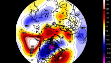
It shouldn't be a surprise that we're looking at a big warm up. This is a classic La Nina setup with a powerful southeastern ridge flexing it's muscle. Colder temperatures with a trough out west and warmer temperatures with a ridge out east. The 6-10 day 500mb anomalies show this quite well with a very amplified jet stream pattern.

Beyond day 10, however, there are some caution flags that our computer models are throwing up. The biggest is the large and impressive -NAO that develops over Greenland as a powerful Rex Block sets up over the North Atlantic. The -NAO may modulate the storm track so that what would have been warm cutters manage to slide nearby or underneath New England. This will have to be watched.
Local


The bottom line is that above normal - and possibly record - wamth is possible in the day 7-10 range. Beyond that, however, I wouldn't write off winter yet!
