
8:30 p.m. Update: The storm is behaving as expected so far. Winds are now gusting to 37 mph in Groton and we have a handful of power outages across the state.

The key is still how much wind will be able to mix down to the surface from aloft. We have a rapidly deepening low off the coast of Delaware lifting north. You can see 3 hour pressure falls in excess fo 9mb/3hr moving north!

Aloft, our models still show an exceptionally powerful low level jet overhead around midnight. The winds about 5,000 feet above our heads will be in excess of 100 mph. While most of this will not reach the surface some of it may.
The HRRR model insists a period of destructive winds even inland. That remains a possibility though most of our models keep a narrow stable layer near the surface which will effectively prevent the strongest winds from mixing down. With the potential for convection, gravity waves, and an impinging dry slot I am concerned for gusts in excess of 60 mph statewide. Right now our forecast is for 60-70 mph gusts at the coast and 45-60 mph inland but there is a low risk for the entire state going above 60 mph. With tremendously saturated soil after recent rain a large number of uprooted trees is possible.
Earlier update: A powerful storm which may set records for sea level pressure in October across New York State is likely to produce a brief period of strong damaging wind tonight across the state. The most likely location for damaging winds is along the shoreline where it's not out of the question that winds could gust to hurricane force!!

The storm that develops will be quite intense. Most of our computer models show a storm with a pressure below 980 mb cutting to our west. This will put us on the windy side of the storm. Most of our computer models show a low level jet somewhere between 60 knots and 100 knots overhead between 10 p.m. and 2 a.m. While winds about 5,000 feet above our heads will be that of a category 2 or 3 hurricane the question is how much of that will mix down to the ground.

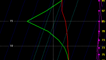
Generally, you need an unstable layer near the ground to mix the stronger momentum down. This sounding from the High Resolution Rapid Refresh for tonight in Groton shows the potential for 76 knots of wind (85 mph or so) to mix from that low level jet to the ground due to a shallow unstable layer near the surface (temperatures drop rapidly with height). Other models do not show this feature and keep much more of the wind bottled up above our head. Other things, however, can mix damaging winds to the surface including convection (thunderstorms) that induce vertical circulations and gravity waves which can do the same. We're forecasting wind gusts over 60 mph at the coast and at this time there is a possibility for hurricane force wind gusts around 75 mph!

This is a classic setup for damaging wind. Something called a tropopause fold will develop right overhead. This is something we see only in the most intense storms. Effectively, the stratosphere (the layer right above the troposphere) will lower to about 8,000 feet above our heads. A dramatic increase in Ozone will occur at this height. Also, we can see a distinct warm core to this low which tends to happen only in some of the most intense Atlantic cyclones. In fact, 850mb temperatures exceed 20C off the Jersey shore!

It's really no surprise the atmospheric pressure will plummet. Here's a look at the European Ensemble forecast for this storm - notice a number of lows with pressures below 970mb! If you compare this to record low October pressures this one is outside of climatology for a good chunk of the northeastern U.S. if you exclude Sandy.


In terms of rainfall 1"-3" of rain is likely across Connecticut with some potential for heavier totals out in western Connecticut. After totals near 5" in some towns last week there may be more uprooted trees than usual given the saturated soil and weakened roots. Flooding is not expected to be a major concern.
Local


Be prepared to lose power and we may have issues Monday morning with downed trees and lines. Be careful driving late tonight during the brief, but wild, peak of the storm.
