
High pressure is controlling New England's weather and that means it will be dry through Wednesday. Temperatures will be near or above average.
Temperatures will fall into the upper 20s and lower 30s tonight with clear skies. That's slightly below average.
Tomorrow's also sunny, but it will be much cooler as high pressure pumps in air from eastern Canada.
The upper atmosphere will be warm, but the surface wind direction dictates what Connecticut will experience. High temperatures will only be in the upper 40s and lower 50s.
Clouds rapidly increase on Wednesday ahead of the next weather-maker. Temperatures will be in the lower 50s.
Rain will fall heavily at times on Thursday, likely skewed towards the second half of the day. Some of the rain could linger into Friday morning. Temperatures will be unseasonably warm, in the middle and upper 50s.
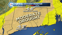
1 to 2 inches of rain are possible from the storm, and that would help the deficit that currently exists across the state.
The weekend looks mainly dry, especially Saturday, though rain or snow showers are possible Saturday night.
