
A First Alert is in effect for accumulating snow as we head into your Saturday. A fast-moving clipper system will swing by to our south during the day.
Take a look at Interactive Radar which shows the system to our west.
We are expecting snow to develop during the midday hours on Saturday, and last into the evening before ending around 7 to 8 p.m. The snow will fall at a light, to at times moderate rate today, especially along the shoreline.
With air temperatures being in the upper teens to lower 20s, this will be a very light and fluffy snowfall, of which will accumulate very easily.
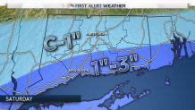
We anticipate a coating to 1" of snow across northern Connecticut, and 1-3" of fluffy snow along the Connecticut shoreline. If you have any travel plans, keep in mind there will be some slick spots on the roadways during the second half of the day.
The snow will be extremely light and fluffy which will make it very easy to move.
Local


In the wake of this minor snowfall, another shot of arctic air moves in for Sunday. Temperatures will be in the single digits above 0 around midnight Sunday to welcome in 2018. Dress very warmly if heading out to any outdoor plans.
Stay with NBC Connecticut's team of meteorologists on air and online for further updates.
